It's not a very busy road, it was something like 30k vehicles per day, which is very low for a motorway around a city. We have single carriageway roads with that level of trafficI wonder how much road congestion etc is being caused by the loss of the bridge. For instance the problems caused by loss of the road crossing might be responsible for more than the six deaths so far. Extra pollution on alternative routes that get over congested and more accidents. Not significant per month but maybe over a very long time. How long for a replacement bridge ?.
-
Our booking engine at tickets.railforums.co.uk (powered by TrainSplit) helps support the running of the forum with every ticket purchase! Find out more and ask any questions/give us feedback in this thread!
You are using an out of date browser. It may not display this or other websites correctly.
You should upgrade or use an alternative browser.
You should upgrade or use an alternative browser.
Collision of cargo ship with, and collapse of, Francis Scott Key Bridge in Baltimore (26/03)
- Thread starter Sun Chariot
- Start date
Sponsor Post - registered members do not see these adverts; click here to register, or click here to log in
R
RailUK Forums
Peter Sarf
Established Member
True enough. If the traffic had been really heavy then the bridge would have been supplemented. Like the Fourth river road crossings (in the UK) where the older one is wearing out and the newer one had to be built to relieve the older one.It's not a very busy road, it was something like 30k vehicles per day, which is very low for a motorway around a city. We have single carriageway roads with that level of traffic
I have wondered how the Fourth river rail bridge would cope ?. I guess it is a huge over engineered (Victorian) structure that might just get scratched !. There is of course a much wider shipping lane between the piers but the piers themselves - would they be strong enough ?. Furthermore the steel structure could be clipped by a ships superstructure/containers as it seems lower at the ends compared to the bridge in Baltimore.
swt_passenger
Veteran Member
- Joined
- 7 Apr 2010
- Messages
- 31,603
The three “Forth” bridges cross the Firth of Forth. (That’s the name of the sea inlet.) If I remember correctly from passing under it on a ship many years ago, only the northern span of the rail bridge is normally used by shipping. There is also only one ship allowed under the bridge at a time in a single direction, so all shipping traffic will pass centrally under the level span to keep well clear of both of the piers. From the seaward side the central pier is sort of guarded behind an island in the middle of the Forth. I also suspect the way it works is that any ship lined up correctly with the centre of the rail bridge northern span will be well clear of the road bridge piers.True enough. If the traffic had been really heavy then the bridge would have been supplemented. Like the Fourth river road crossings (in the UK) where the older one is wearing out and the newer one had to be built to relieve the older one.
I have wondered how the Fourth river rail bridge would cope ?. I guess it is a huge over engineered (Victorian) structure that might just get scratched !. There is of course a much wider shipping lane between the piers but the piers themselves - would they be strong enough ?. Furthermore the steel structure could be clipped by a ships superstructure/containers as it seems lower at the ends compared to the bridge in Baltimore.
Last edited:
Also the influence of tidal currents? The Forth Bridge is surrounded by deep water most of the time, and is a firth rather than an estuary - and narrows significantly as you go upstream. It seems that the maximum current is about 5 knots, whereas Baltimore Bay (or whatever is is) is very wide upstream of the bridge, maybe there is a stronger flow there?The three “Forth” bridges cross the Firth of Forth. (That’s the name of the estuary.) If I remember correctly from passing under it on a ship many years ago, only the northern span of the rail bridge is normally used by shipping. There is also only one ship allowed under the bridge at a time in a single direction, so all shipping traffic will pass centrally under the level span to keep well clear of both of the piers. From the seaward side the central pier is sort of guarded behind an island in the middle of the Forth. I also suspect the way it works is that any ship lined up correctly with the centre of the rail bridge northern span will be well clear of the road bridge piers.
paul1609
Established Member
Its a toll bridge like the Dartford Crossing on the M25. I think the toll booths were removed just before 2020. Its all APNR now. It will have stop lights like most highways.Apparently this was a toll bridge, so a quick message to control from the Port authority/Coastguard and the gates could be stopped from letting more vehicles onto the bridge in short order.
Peter Sarf
Established Member
+Apparently this was a toll bridge, so a quick message to control from the Port authority/Coastguard and the gates could be stopped from letting more vehicles onto the bridge in short order.
If it was like the Dartford Crossing or indeed the Severn Crossing with the toll booths all on one side then there would have been a solid queue of vehicles on one carriageway of the bridge if the collision had happened during peak traffic hours.Its a toll bridge like the Dartford Crossing on the M25. I think the toll booths were removed just before 2020. Its all APNR now. It will have stop lights like most highways.
Enthusiast
Established Member
- Joined
- 18 Mar 2019
- Messages
- 1,204
I believe it would have put up much more of a fight.I have wondered how the Fourth river rail bridge would cope ?.
The structural elements that any ship would have collided with are not brittle concrete. They are steel tubes large enough to accommodate a London tube train. The four piers upon which each of the cantilever supports rest are of solid granite construction. As mentioned, the north cantilever piers are protected on the seaward side by Inchgarvie island (in fact two of the four piers are built on it). I believe there is shallow water on the inland side of those piers, probably shallow enough t run a ship aground before it got to the bridge. Although an individual cantilever would be damaged in any collision, I imagine the damage would be restricted and I doubt the entire bridge would have collapsed.
It's an altogether different ball game, as these pictures of the bases of the two bridges illustrate:

Last edited:
DelW
Established Member
- Joined
- 15 Jan 2015
- Messages
- 3,959
As they *used* to be, maybe, but neither of those crossings has had toll booths or barriers for many years now. I believe the Baltimore bridge was similar in having no physical barriers.If it was like the Dartford Crossing or indeed the Severn Crossing with the toll booths all on one side then there would have been a solid queue of vehicles on one carriageway of the bridge if the collision had happened during peak traffic hours.
The largest crane on the eastern seaboard has been brung in to help move the bridge. It sits on a barge & can lift 1,000 tonnes. It is one of at least 2 large cranes that will be needed to move the bridge.
2 bodies have been recovered from a vehicle in the water but to recover the other’s debris needs to be moved.
2 bodies have been recovered from a vehicle in the water but to recover the other’s debris needs to be moved.
Is that two more, or the two that were recovered earlier?2 bodies have been recovered from a vehicle in the water but to recover the other’s debris needs to be moved.
GRALISTAIR
Established Member
I will let you all know what I-95 traffic and others roads in the area are like on Sunday. I am going tomorrow. I fly into Philadelphia from Chattanooga via Charlotte and renting a car and driving over a few bridges in Pennsylvania, New Jersey, Delaware and Maryland.
Is that two more, or the two that were recovered earlier?
That is the two in the van. The other 4 bodies can’t be recovered until the debris is removed
GRALISTAIR
Established Member
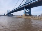
These were taken from Camden NJ looking towards Philadelphia PA across the Delaware river. Older bridges as you can see are a lot more substantial.
I did not get to Baltimore- traffic too bad because of the bridge out.
I did not get to Baltimore- traffic too bad because of the bridge out.
Attachments


Last edited:
The much more substantial piers are as much a function of it being a suspension bridge as due to its age. They need to be able to sustain much greater loads than a through truss bridge, the entire weight of the bridge resting on just two piers, as opposed to being distributed across four or more.These were taken from Camden NJ looking towards Philadelphia PA across the Delaware river. Older bridges as you can see are a lot more substantial.
Clearance work has started:
-------------------------
There is now a channel open for smaller vessels:
-------------------------
The US Army Corps of Engineers said today that they expect to have a limited access channel open by the end of April. This will be 35 feet deep vs the main channel's 50 feet. Their aim is to have the original channel open by the end of May.
Last edited:
The bridge arch was made of steel i form of a bent pipe. The bridge deck was of concrete. MAN was the builder and I have seen a model of the bridge at Deutsches Museum in München.The Almö bridge in Sweden was a standard concrete type bridge: https://www.reddit.com/r/CatastrophicFailure/comments/lfaawk/the_almö_bridge_in_sweden_collapsed_at_0130_am_on/
swt_passenger
Veteran Member
- Joined
- 7 Apr 2010
- Messages
- 31,603
6 weeks or so into the response to this incident, the ship is still in position. The last of 6 bodies was recovered only a few days ago. It was announced yesterday that the large section of bridge resting on the MV Dali’s port bow will be explosively demolished on Saturday evening.
I’ve attached a screen shot from a YouTube live video stream covering the response, shows a front view of the container ship Dali, the bow is aground and low in the water under the weight of debris from the destroyed bridge pier, the road surface, and a bridge truss section. To the starboard side of the ship (left of shot), a variety of floating cranes continue the conventional dismantling effort. Hope this is of interest:
I’ve attached a screen shot from a YouTube live video stream covering the response, shows a front view of the container ship Dali, the bow is aground and low in the water under the weight of debris from the destroyed bridge pier, the road surface, and a bridge truss section. To the starboard side of the ship (left of shot), a variety of floating cranes continue the conventional dismantling effort. Hope this is of interest:
Attachments

Last edited:
edwin_m
Veteran Member
Importantly though, part of the channel has been cleared of debris so ships can now enter and leave the port.6 weeks or so into the response to this incident, the ship is still in position. The last of 6 bodies was recovered only a few days ago. It was announced yesterday that the large section of bridge resting on the MV Dali’s port bow will be explosively demolished on Saturday evening.
I’ve attached a screen shot from a YouTube live video stream covering the response, shows a front view of the container ship Dali, the bow is aground and low in the water under the weight of debris from the destroyed bridge pier, the road surface, and a bridge truss section. To the starboard side of the ship (left of shot), a variety of floating cranes continue the conventional dismantling effort. Hope this is of interest:
Mcr Warrior
Veteran Member
- Joined
- 8 Jan 2009
- Messages
- 12,245
That's something. How long is the road detour that's needed now that the bridge is no longer able to be used?Importantly though, part of the channel has been cleared of debris so ships can now enter and leave the port.
swt_passenger
Veteran Member
- Joined
- 7 Apr 2010
- Messages
- 31,603
Yes, it’s been said their visa status only allows short escorted periods ashore.Are the crew still on the ship?
DelW
Established Member
- Joined
- 15 Jan 2015
- Messages
- 3,959
AIUI (from various American news channels' bulletins posted to YouTube) the main channel was reopened for a limited time to get certain ships in and out, but was then closed again to allow the removal of bridge sections that had fallen across the ship's bow. There are shallow draught channels passing to the side of the fallen bridge sections that are still available for barge traffic, but not ocean-going vessels.Importantly though, part of the channel has been cleared of debris so ships can now enter and leave the port.
61653 HTAFC
Veteran Member
The short answer is "it depends". Anything carrying hazardous materials (including propane bottles) is barred from the tunnels beneath Baltimore harbour so must use the I-695 Baltimore Beltway (note that the route over the Key Bridge was also designated I-695. American road numbering is confusing!) which adds significant mileage. Vehicles which can use the tunnels will only have a small increase in mileage but will suffer significant delays. The Key Bridge was built to reduce congestion in those tunnels, so with the bridge out-of-action those tunnels will be pretty busy.That's something. How long is the road detour that's needed now that the bridge is no longer able to be used?
FormerBritInMe
Member
In the US, Interstate Highways with 3 digits are either spurs (first digit an odd number e.g. I-195, I-395) or circumferential "belt" highways (first digit is even e.g. I-695). The 2nd and 3rd digit refers to the major highway (e.g. I-95) that they are a spur or beltway off of. The Beltway plus the Key Bridge section forms a complete circle around the city (or did until the bridge collapsed). So it's not really confusing if you understand the numbering system which is quite different from British practice AIUI.Anything carrying hazardous materials (including propane bottles) is barred from the tunnels beneath Baltimore harbour so must use the I-695 Baltimore Beltway (note that the route over the Key Bridge was also designated I-695. American road numbering is confusing!)
What is probably more confusing is probably that we have so many different categories of highways - Interstate, US highways (both part of the Federal system), state highways with their own numbering systems, and sometimes lower categories such as numbered county roads, farm to market roads (Texas), etc. Whereas you just have M, A, and B roads.
DelW
Established Member
- Joined
- 15 Jan 2015
- Messages
- 3,959
To be fair, it's not really any different from the M25 which has two routes from e.g. Heathrow to Dartford, one going north of London and one south (ignoring the tunnel itself not actually being motorway for various reasons). So if one was blocked you could make the journey by an entirely different route but still be going "via the M25".In the US, Interstate Highways with 3 digits are either spurs (first digit an odd number e.g. I-195, I-395) or circumferential "belt" highways (first digit is even e.g. I-695). The 2nd and 3rd digit refers to the major highway (e.g. I-95) that they are a spur or beltway off of. The Beltway plus the Key Bridge section forms a complete circle around the city (or did until the bridge collapsed). So it's not really confusing if you understand the numbering system which is quite different from British practice AIUI.
61653 HTAFC
Veteran Member
Thanks... so I suppose the I-695 is a little bit like Manchester's M60 outer ring road, in that it has a unified number to form an orbital route, but is largely patched together from bits of other highways to form the circle?In the US, Interstate Highways with 3 digits are either spurs (first digit an odd number e.g. I-195, I-395) or circumferential "belt" highways (first digit is even e.g. I-695). The 2nd and 3rd digit refers to the major highway (e.g. I-95) that they are a spur or beltway off of. The Beltway plus the Key Bridge section forms a complete circle around the city (or did until the bridge collapsed). So it's not really confusing if you understand the numbering system which is quite different from British practice AIUI.
What is probably more confusing is probably that we have so many different categories of highways - Interstate, US highways (both part of the Federal system), state highways with their own numbering systems, and sometimes lower categories such as numbered county roads, farm to market roads (Texas), etc. Whereas you just have M, A, and B roads.
FormerBritInMe
Member
That's entirely possible although I don't know the history of Baltimore's I-695. But that has happened in other places.Thanks... so I suppose the I-695 is a little bit like Manchester's M60 outer ring road, in that it has a unified number to form an orbital route, but is largely patched together from bits of other highways to form the circle?
For example in the Boston metro area, where I lived at one time, the original plan was to build I-95 through the middle of the city, destroying inner city neighborhoods many of them mostly minority residents. Fortunately there was a rare moment of common sense where the project was canceled and instead the existing state circumferential highway 128 was rebadged as I-95 (it probably would have become I-295 otherwise) and some of the right of way intended for I-95 through the city was used to reroute the Amtrak/MBTA Northeast Corridor off of its "Chinese wall" and also to replace an elevated transit line. An instance of favoring transit over highways which is rare in this country. I know this isn't exactly the same situation but it is the first one that came to mind.